
Hidalgo County ZIP Code Coverage
The working research set contains 31 distinct ZIP codes associated with Hidalgo County communities or routes. It is a carefully bounded starting list, not a county boundary map or a substitute for a USPS response for one address. The area and post-office entries below are postal or community leads from Texas agency cross-checks. Where the research describes a code as a PO box-style association or possible route, that limitation stays visible.
| ZIP | Areas | Post office / area lead | Notes |
|---|---|---|---|
| 78501 | McAllen | McAllen | Postal city/area; verify the street |
| 78502 | McAllen | McAllen | Postal or PO box-style association; verify USPS |
| 78503 | McAllen | McAllen | Postal or PO box-style association; verify USPS |
| 78504 | McAllen | McAllen | Postal city/area; verify the street |
| 78505 | McAllen | McAllen | Postal or PO box-style association; verify USPS |
| 78516 | Alamo | Alamo | City association in the TxDOT list |
| 78537 | Donna | Donna | City association in the TDI appendix |
| 78538 | Edcouch | Edcouch | City association in the TDI appendix |
| 78539 | Edinburg | Edinburg | TDI city association; USPS verification needed |
| 78540 | Edinburg | Edinburg | May include routes or PO boxes |
| 78541 | Edinburg | Edinburg | May include routes or PO boxes |
| 78542 | Edinburg | Edinburg | May include routes or PO boxes |
| 78543 | Elsa | Elsa | City association in the TDI appendix |
| 78549 | Hargill | Hargill | Community association in the TDI appendix |
| 78557 | Hidalgo | Hidalgo | City association in TDI and TxDOT materials |
| 78558 | La Blanca | La Blanca | Community association in the TDI appendix |
| 78560 | La Joya | La Joya | City association in the TDI appendix |
| 78562 | La Villa | La Villa | City association in the TDI appendix |
| 78563 | Linn | Linn | Community association in the TDI appendix |
| 78565 | Los Ebanos | Los Ebanos | Community association in the TDI appendix |
| 78570 | Mercedes | Mercedes | City association in the TDI appendix |
| 78572 | Mission | Mission | City association in TDI and TxDOT materials |
| 78573 | Mission | Mission | City association in the TDI appendix |
| 78574 | Mission | Mission | City association in the TDI appendix |
| 78576 | Penitas | Penitas | City association in the TDI appendix |
| 78577 | Pharr | Pharr | City association in TDI and TxDOT materials |
| 78579 | Progreso | Progreso | City association in TDI and TxDOT materials |
| 78589 | San Juan | San Juan | City association in the TDI appendix |
| 78595 | Sullivan City | Sullivan City | City association in the TDI appendix |
| 78596 | Weslaco | Weslaco | City association in TDI and TxDOT materials |
| 78599 | Weslaco | Weslaco | Verify the exact street with USPS |
Texas Department of Insurance rows and the TxDOT Pharr District material supplied cross-checks for these community associations. Neither source is a USPS master or a parcel-boundary file. USPS street-level verification controls whenever the sources differ.
Find Addresses by Hidalgo County ZIP
Use the USPS ZIP Lookup before relying on any entry in the table. By Address takes an optional company, required street address, optional apartment or suite, city, state, optional ZIP, and a Find command. By City and State takes city and state. Cities by ZIP takes a ZIP and returns associated city names. These are three different questions, so choose the tab that matches the information in hand.
- Keep the supplied address exactly as received, including the unit and postal city.
- Run USPS By Address and save the standardized response, including ZIP+4 when returned.
- Use Cities by ZIP only to identify associated city names, not to establish a municipal boundary.
- Check the address point and city-limit context in the county ArcGIS layers when a parcel or jurisdiction matters.
- Use the tax account, HCAD, or County Clerk record only after the postal address has been normalized for that source.
USPS notes that a returned business address does not guarantee a physical location, and multiple results may need narrowing. That limitation matters when a ZIP label is being used to guide a records search rather than mail delivery.
For a broader postal cross-check, the USPS City State Product is a monthly reference for city, county, and post-office names attached to ZIP codes. It is not a street-detail source, and its raw data is protected from ordinary export. The research observed an August 24, 2026 update on that product page. Use its naming information to compare a code, then return to USPS By Address for the current street-level answer.
Hidalgo County ZIP Search Fields
No verified Hidalgo County portal in the research exposes a ZIP filter for a resident or parcel result. The tax portal is useful after a ZIP has narrowed the address, but it should not be described as a ZIP-search tool. Its verified controls are shown below, and its property-address mode is a starts-with search rather than an exact street-level geography filter.
| Tax portal field | Search mode | Verified example or restriction |
|---|---|---|
| Owner Name | Step 1, last name first | smith mary |
| Property Address | Step 1, starts with | 905 Oak Park |
| Account No. | Step 1 identifier | 304900000001 |
| CAD Reference No. | Step 1 identifier | R071466 |
| Fiduciary No. | Step 1 option | 586590; portal warns it may take several minutes |
| Optional Step 2 | Owner, address, account, or CAD reference | May narrow a Step 1 search |
The Hidalgo County tax portal is the source captured for those fields.
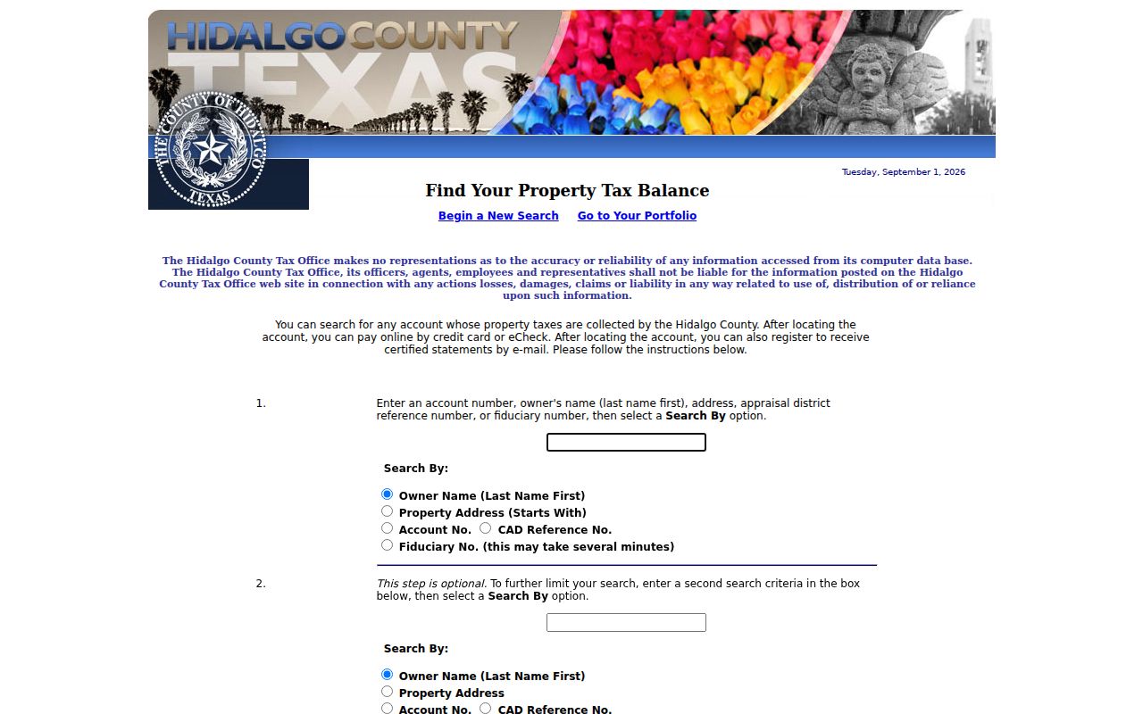
The screenshot documents the owner, property-address, account, CAD-reference, and fiduciary entry paths. It does not support a claim that the portal filters results by ZIP or that its database has a stated historical cutoff.
Hidalgo County ZIP Code Geography
A ZIP code is a postal delivery area. It is not a city-limit polygon, a county boundary, or proof of an address's legal jurisdiction. Hidalgo County's geography includes separate urban-county communities and the cities of Edinburg, McAllen, and Mission, while county profile material also identifies McAllen, Pharr, Mission, Weslaco, Mercedes, and county-seat Edinburg as major cities. Show the postal city and the legal municipality separately when the difference matters.
- ZIP code
- A five-digit Postal Service routing code used for delivery, not a local-government boundary.
- ZIP+4
- An added four digits that USPS may return for a more specific delivery segment of a standardized address.
- PO box-style association
- A code whose research note signals a postal or PO box-style relationship. Verify the exact street-level answer with USPS.
- Unique ZIP
- A ZIP assigned to a particular organization or use. The research did not identify one as a general Hidalgo County community boundary.
- Carrier route
- A mail-delivery grouping. It is not evidence that all addresses in it share one city or county jurisdiction.
Hidalgo County ZIP Code Mismatches
Start with a mismatch as a verification task, not an error to repair by guesswork. The Postal Service's City State Product is updated monthly and carries ZIP, city, county, and post-office names, but it does not provide street details. It cannot allocate a parcel to a city without GIS or official boundary evidence. The product is useful for postal reference, while an address-point or city-limit layer answers a different question.
The research expressly excludes nearby or split codes such as 78545, 78547, 78548, 78559, 78564, 78566, 78569, and 78580 from the Hidalgo-verified working set. A code appearing in a congressional, mailing, or nearby-county list is not enough. For example, the USPS facility material associates 78559 with La Feria and 78566 with Los Fresnos, both Cameron County leads rather than Hidalgo rows.
Postal limit. Use a ZIP code to confirm delivery information, then use the appropriate Hidalgo County map or custodian record to determine parcel and municipal context.
Hidalgo County Postal Facility Tip
The McAllen Processing and Distribution Center at 620 E Pecan Boulevard is identified in a USPS McAllen facility release. USPS location material also lists Downtown McAllen, the McAllen P&DC, and offices in Mission, Edinburg, Pharr, and San Juan. These facilities explain local routing context. Their facility ZIPs do not define the full postal or municipal reach of those places.
This is the practical postal myth to avoid: a mail-processing address may be in one ZIP, while the delivery territory it handles reaches many ZIPs and communities. Use the actual street address in USPS rather than inferring a boundary from a facility location.
The same caution applies to the research table. Codes 78539 through 78542 are associated with Edinburg in the Texas source cross-check, while 78572 through 78574 are associated with Mission. Those associations help select a USPS query, but they do not draw a line around a city or establish a parcel's jurisdiction. The county profile distinguishes its urban-county communities from Edinburg, McAllen, and Mission, and the ArcGIS city-limit layers answer a different geographic question from USPS. When a postal label and map context differ, preserve both results with their sources rather than selecting the one that feels more familiar.
Hidalgo County Parcels After ZIP
Once USPS returns a standardized address, move from postal geography to property geography. The county ArcGIS inventory includes HC_Address_Points, HC_Parcel, rural addressing, City Limits, and Hidalgo County City Limits. A point can establish mapped context and a parcel can point toward appraisal or tax material, but the research did not capture the live identify popup, neighbor display, print control, export control, or layer refresh schedule.
HCAD remains the official appraisal route identified by the county FAQ, although its interactive field labels were not exposed during the research. The tax portal can locate an account by owner, property address, account number, CAD reference, or fiduciary number. Check those sources against the recorded legal description when an address, mailing label, and parcel do not agree. For a full street-by-street property chain after a ZIP has narrowed the area, use the Hidalgo County street directory.
Historic Hidalgo County ZIP Labels
Keep a date beside any historical address. USPS standardization answers a current mailing question, while older documents may preserve another street spelling, a rural-route description, a survey, or a porción. The research recommends retaining the original address string and keeping postal city and legal municipality in separate fields. If no official address-equivalency record is found, state that it was not located instead of assigning a modern ZIP by assumption.
For older place research, the Library of Congress map records include a six-sheet Mission set dated 1933-1949 and an eight-sheet McAllen map dated March 1925. Those maps can add a date and street context, but do not provide a resident roster. A date-aware search prevents a current ZIP code from being presented as if it belonged to an older record.
Note: The USPS City State Product supplies ZIP, city, county, and post-office names monthly, but not street-level history or legal parcel boundaries.